


By Isobel Campbell and Hazel Ross
The West Coast wilderness is a must-visit location for more than just glaciers. In this blog we cover some of the awesome spots in this untamed West Coast wilderness surrounding Franz Josef Glacier and north of the Waiho river toward Hokitika.
Where the mountains meet the sea, the unique intersection of ancient vegetation, glaciated valleys, and coastal ecosystems has created a land of hidden gems. Containing part of the Te Wāhipounamu – South West New Zealand UNESCO World Heritage area, the almost untouched landscape is the world’s best representation of the ancient lands of Gondwana. That’s pretty special. So, as you plan your South Island road-trip, it is well worth adding a few of our favourite West Coast walks and stops to the list.

Photographer: Petrus Hedman
Tartare tunnels – 1 hr 20 min return
Got a glow-worm craving? Then it’s time to go caving! In the Tartare tunnels located behind Franz Josef township you can see these little critters anytime of the day or night. Constructed in 1897 for gold mining operations, the historic tunnel stretches several hundred metres, creating a pitch-black environment perfect for spotting glow-worms. This is a great walk for the kids and a bit more adventurous with ankle-deep water through the tunnel, so an extra pair of shoes and a flashlight is handy.

Photographer: Petrus Hedman

Photographer: Isobel Campbell
Callery Gorge – 1 hr 30 min return
Wandering up through temperate rainforest, the track then drops down a rocky slope to the rushing Callery Gorge. Walk out onto the historic bridge to nowhere and watch the mesmerising power of the water carving through the rock walls. If you listen closely you might even hear boulders rumbling down the riverbed. As you walk through the forest, keep an eye out for some of the incredible birdlife including fantails, tomtits, and kererū if you are lucky!

Photographer: Petrus Hedman


Photographer: Glacier Country Kayaks Ltd.

Photographer: Glacier Country Kayaks Ltd.
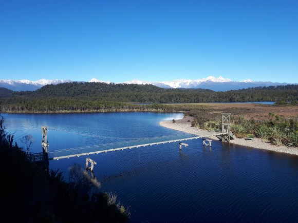
With excellent mountain views Lake Mapourika is the perfect place to park up for a swim, some fishing (don’t forget a license) or a tasty picnic. The best spot for a dip is the lakeside beach behind DOC’s Otto campsite and is regularly frequented by locals. Just make sure you watch out for eels! If you are looking for somewhere to pitch your tent the campsite offers great facilities, excellent star gazing and picturesque sunsets with snow-capped mountains often mirrored in the lake.

Photographer: Petrus Hedman

Photographer: Petrus Hedman
Tucked a 30-minute drive north of Franz Josef, this historic coastal settlement is one of the West Coast’s hidden gems. Not only is it home to New Zealand’s rarest kiwi, the rowi, it also contains New Zealand’s largest coastal wetland. The Ōkārito Lagoon is packed full of birdlife from kōtuku/white heron to royal spoonbill and can be explored by kayak or on a guided nature tour. The surrounding bush and coastline can be discovered independently on foot with walks for different abilities and fitness levels.
Photographer: Cisco Fahnestock

Photographer: Petrus Hedman

Photographer: Hazel Ross
3 Mile Pack Track – 3 hr 30 min loop
Previously used to link Ōkārito to the historic gold mining towns of Three Mile and Five Mile in the 1860s, this historic pack track sets off through coastal forest before descending to Three Mile Lagoon. Particularly spectacular at sunset, this spot has incredible views along pristine coastline. Penguin tracks are a common along the beach so keep an eye out, and if you’re lucky you may even see the real thing! The track returns along the coast. This section can only be done at low tide so check the times before you head off (they’re printed in the carpark) or return along the inland track if it is not low tide.

Photographer: Cisco Fahnestock

Photographer: Cisco Fahnestock
Ōkārito Trig Walk – 1 hr 30 min return
A shorter, but equally spectacular alternative is the Ōkārito Trig Walk. It even has glacier views on a clear day! Branching off from the Three Mile Pack Track this walk climbs steeply to the trig point at 158 m. The viewpoint provides incredible panoramic views of native forest, the Southern Alps’ snow-capped peaks, and the Ōkārito lagoon and coast. This trig was used in 1865 when the West Coast was first mapped. From here you can clearly see the valleys carved out by glaciers 14000 years ago.

Photographer: Petrus Hedman
If you’re accompanied by little legs or are short on time the Pakihi Walk is a good alternative to the Trig Track. It starts by crossing swamp lands before steadily climbing through kamahi and rimu to a viewpoint overlooking the Ōkārito lagoon and Southern Alps. Stay alert for wildlife as visitors often spot curious kea and at night you may be lucky enough to hear kiwi calling in the forest.

Photographer: Robert Schadewinkel
Mahinapua Walkway – 2 hr – 2 hr 30 min one way
A stone’s throw from SH6 and Hokitika, Lake Mahinapua is surrounded by a range of great walks, swimming spots and opportunities for boating. In particular, the Mahinapua Walkway is fantastic for both walkers and cyclists alike. Part of the longer West Coast Wilderness Cycle Trail, the route follows a historic logging tramline and passes through wetland areas by boardwalk. The Picnic Bay side track is a worthwhile detour offering excellent mirror lake views.
Hokitika Gorge – 15 min return
One of the most popular spots near Hokitika, is the Hokitika Gorge which is famous for its stunning bright turquoise-blue waters. Surrounded by lush native bush and topped off with an excellent swing bridge this easy walk is a great photo stop. The first viewpoint is even wheelchair accessible so great for the whole family!
In our next blog we’ll explore the sights south of the Waiho River between Fox Glacier, Haast and beyond.
If you are also looking to visit the glaciers before heading up check the daily status on the Glacier Country Website or at the DOC visitor centre. Sometimes vehicle and foot access can be lost due to storm events and changing conditions in the valley. Both Fox and Franz Josef glaciers are currently inaccessible as of April 2019.However, you can still fly up to the glaciers for the spectacular aerial views or guided walks on the ice. Read about the possibilities for flights and other activities in this article on the Tourism West Coast website.


Yes indeed. A most beautiful part of the world.
Being born and raised in Christchurch, the West Coast had always held a mystique for me, from my dad’s comments about a huge tree fern that had black stipes 2 inches in diameter to the journey from Springfield to Otira and Dobson which was a dramatic contrast in vegetation types.
Later I came to love the incredible biodiversity of the rainforest there: some with North Island origins like tawheowheo (Quintinia acutifolia) and hutu (Ascarina lucida) to montane elements such as mountain toatoa and Prince of Wales fern (Todea superba). I used to spend hours exploring and it was back in the 1960s that I heard and saw South island kokako.
In the Berlins pub in the Buller Gorge, what should I discover but a weka boldly striding among the tables and chairs of the public bar and, when I was invited around the back, there was this same weka happily sharing a bowl of food with a kunikuni pig, a rooster and two kittens. Elsewhere, one of the local attractions for tourists was a kea, very happily co-existing with humanity and showing no desire to leave the bar. He was a mature male with a frighteningly large and hooked bill!
From a tourism perspective, while I haven’t been there since the 1990s, this is the West Coast I remember, along with happy times at Okarito among to locals for New Year’s massive bonfires. It was there I met a famous local, Kerry Hulme.
It was a very special place and I hope it never loses its identity and hospitality. It worries me that so many tourism ventures appear to be compromising the tranquility of the more remote and inaccessible areas – overly frequent helitours to the dwindling glaciers for example and the plans to allow dogs within the national park, especially within or close to the rowi areas, or where weka and tokoeka are present. I’m especially concerned about dog breeds like fox terrier that have a propensity to chase ground birds.
A beautiful part of Aotearoa and one area we need to revisit soon. Or perhaps in spring or summer!
South Westland isn’t only about the Glacier townships either as this DOC Blog suggests. South of Fox Glacier there is 200km of road access to the largest expanse of unmodified lowland rainforest in New Zealand. It is almost all permanently protected in the Te wahi pounamu/SWNZ World Heritage Area brilliantly managed by DOC.
For the last 30 years we have welcomed tens of thousands of visitors from throughout the world and shown them these great podocarp -beech rainforests. They have discovered Tawaki, 3rd rarest of the world’s 18 penguin species, NZ Fur seal colonies, elephant seals, extensive lowland wetlands, lakes and estuaries home to rare southern crested grebe, fernbird, bittern, giant long-finned eels. In recent years we have even discovered Fur seals living permanently in freshwater lakes. Visitors can enjoy discovering all these native animals and unmodified ecosystems on a network of wonderful DOC tracks. Moreover they will experience wild nature in silence without the annoying constant buzz of helicopters that blight every Glacier Valley visitor walking experience in the Westland Tai Poutini National Park.
Hi Gerry,
You are absolutely correct that the region is not just about the Glacier townships, there are many fantastic spots to see in the area.
In fact so many that we could not fit them into only one article.
This is why (as stated in the article) that in our next blog we’ll explore the sights south of the Waiho River between Fox Glacier, Haast and beyond.
We’ll be covering some of the fantastic locations and tracks in the area, from Monro Beach, to the Hapuka Estuary, to Mt Fox.
This blog will be coming out very soon
We’ve been trying to tell people for years there is so much more to South Westland than the glaciers – oh so much more.